Hi, this is Higashi.
Last time, I kept the battery charge the same and changed the energy consumption to see how much farther the roads on the map would go. What happens if we compare three cars you can actually buy?
This time I picked the Tesla Model Y, Model Y L, and Model 3. If you start at Tokyo Station with 10% battery left in each car, how far can you go in each direction? I used the Python program from my earlier post to put the results on a map.
Comparing three Teslas at 10% state of charge
I used the Japanese-market Long Range AWD versions of the Model Y and Model 3. All three start at Tokyo Station with a 10% state of charge (SOC). I compared how far each could go one way, without stopping to charge.
| Model | WLTC range on a full charge | WLTC AC energy consumption | Distance limit in this example |
|---|---|---|---|
| Model Y Long Range AWD | 682 km | 139 Wh/km | 68.2 km |
| Model Y L | 788 km | 126 Wh/km | 78.8 km |
| Model 3 Long Range AWD | 757 km | 126 Wh/km | 75.7 km |
The figures come from Tesla Japan’s range specifications, accessed November 18, 2026. Tesla’s Model 3 product page lists a different range, so I used the same specifications table for all three cars.
I wanted to divide the energy left in the battery by the energy used per kilometer, as I did last time. I couldn’t verify both usable battery capacity and battery-side energy consumption on a consistent basis for all three cars. The Wh/km figures in the table are based on AC energy drawn during charging. So for this comparison, I multiplied the full-charge WLTC range by 0.10 to get the distance limit for the road search. For the Model Y, that’s 682 × 0.10, or 68.2 km.
These maps are theoretical estimates based on vehicle specifications and map data published online. They have not been validated by driving the actual cars, and they do not guarantee that the cars can reach every road shown in real-world conditions.
Finding the reachable roads for each model with Python
I reused the program from my post on mapping EV driving range from Tokyo and Osaka Stations. That post includes the code for loading the road data and drawing the results on a map with Pillow.
Here I only changed the distance limit for each car. I used major roads from OpenStreetMap and calculated the shortest driving distances from a point on the road network near Tokyo Station, taking one-way streets into account. All three cars use the same starting point and road data, so a single search up to the longest limit of 78.8 km is enough.
wltc_km = {"Model Y": 682, "Model Y L": 788, "Model 3": 757}
soc = 0.10
limits_m = {model: round(km * soc * 1000) for model, km in wltc_km.items()}

# Calculate the shortest road distances once, using the longest range.
_, _, distances = shortest_distances(graph, coords, origin, max(limits_m.values()))

for model, limit_m in limits_m.items():
    left, right, full, partial = reachable_segments(
        u, v, lengths, direction, distances, limit_m
    )
# Draw the fully and partially reachable road segments for this model.Comparing driving ranges from Tokyo Station on a map
I put the three maps side by side at the same scale and with the same extent. The purple lines show the major roads you can reach within each car’s distance limit.
As a reminder, these maps show the reachable range with just 10% battery remaining.
Under the same assumptions, you can think of a full charge as giving you roughly ten times the driving distance.
If you can go this far with just 10%, a full battery could take you quite a long way!
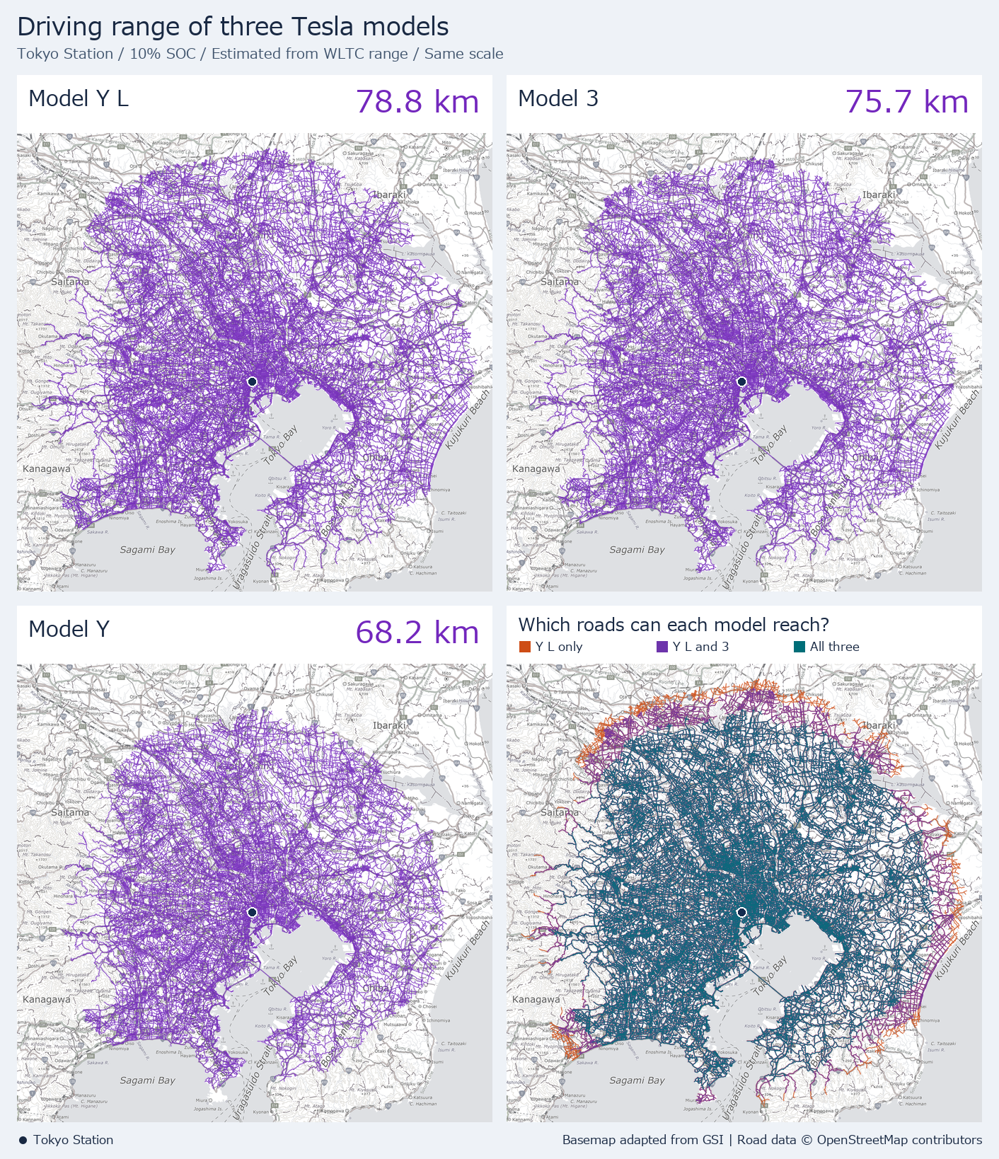
The blue dot marks Tokyo Station. In the bottom-right map, teal shows roads all three cars can reach, purple shows roads the Model Y L and Model 3 can reach, and orange shows roads only the Model Y L can reach.
For example, the calculation put a point on the road near Kozu Station, toward Odawara, about 74.2 km away. The Model Y reaches its 68.2 km limit before that point, while the Model 3 and Model Y L can both reach it within their limits of 75.7 and 78.8 km. A point near Narita Airport Terminal 1 came out at about 65.1 km, within range of all three. Both examples use points on the road network near the station or terminal.
How long did it take?
On my Windows setup, generating one comparison image for the Japanese version took 104.69 seconds (about 1 minute and 45 seconds). That includes reading the previously downloaded nationwide road data, building the road network, calculating the three driving ranges and the example distances, fetching the basemap, and saving the PNG. The initial download of the road data was outside the timed run.
Looking at range on a map when choosing an EV
Under these assumptions, the gap between the Model Y and Model Y L was 10.6 km, and the gap between the Model 3 and Model Y L was 3.1 km. A few kilometers can look small on paper. Looking at roads in a direction you often travel makes it easier to see which stretches those extra kilometers get you to.
Actual range varies with speed, temperature, road gradient, and air-conditioning use. This map assumes WLTC range scales in proportion to SOC. It leaves out a reserve for reaching a charger and turn restrictions at individual intersections. I use it as an estimate for comparing the cars.
If you want to see what changes when the battery capacity stays the same, take a look at my map comparison at 120, 150, and 200 Wh/km.
See you next time!


コメント